Impacted Members/Scientists: Request a membership waiver, seek meeting support, and other resources. Learn more. For the latest public policy updates, please visit this page.
5 October 2017
Try WorldWide Telescope on the Web
![]() WorldWide Telescope (WWT) has been a mainstay in classrooms, museums, and planetariums since its launch as a Windows application nearly 10 years ago. It is a virtual sky, with terabytes of astronomical image overlays incorporating numerous all-sky surveys across the electromagnetic spectrum. It is also a virtual universe, with high-definition base maps of solar-system planets, 3-D star positions, and SDSS Cosmos galaxies. Beyond data visualization, WWT has a rich contextual narrative layer that allows its users to record their path though the program by creating and sharing "tours."
WorldWide Telescope (WWT) has been a mainstay in classrooms, museums, and planetariums since its launch as a Windows application nearly 10 years ago. It is a virtual sky, with terabytes of astronomical image overlays incorporating numerous all-sky surveys across the electromagnetic spectrum. It is also a virtual universe, with high-definition base maps of solar-system planets, 3-D star positions, and SDSS Cosmos galaxies. Beyond data visualization, WWT has a rich contextual narrative layer that allows its users to record their path though the program by creating and sharing "tours."
Since the AAS took on WWT management, we have been working with the WWT developers to make the program work as well for AAS members as it does for its other 12 million users around the world. Most US astronomers today are not using Windows machines, so we're excited to announce a new version of WorldWide Telescope for the web, agnostic of your underlying operating system.
Try WorldWide Telescope on the Web
Looking Ahead
We are working to enhance WWT to seamlessly integrate it into the research and publishing process. We have many more exciting features and projects in the pipeline. If you would like to stay up to date, please join our general email list.
Sign up for WWT Training Sessions
We will be offering online training sessions in several WWT-related topics. If you are interested in joining us, please fill out our expression-of-interest form.
See You at AAS 231!
Be on the lookout for our "WWT in Astronomical Research" workshop at the AAS winter meeting, as well as WWT office hours at the AAS booth in the Exhibit Hall and WWT-related hacking at the AAS 231 Hack Together Day.
 |
 |
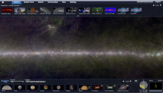
Left: Screen shot of IRIS (infrared sky) shown in the WWT Web client using the Sky view.
(IRIS credit: Infrared Science Archive (IRSA) at Caltech)
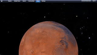
Right: Screen shot of Mars and Orion shown on the WWT webclient in 3D Solar System view.
(Mars credit: NASA/USGS/Malin Space Science Systems/JPL; Digitized Sky Survey Credit: DSS Consortium)